


Profiteer t/m 2 mei
BekijkActivities
- Walking & Trekking
- Point-to-Point
- Natural Wonders
- Improved route using New Annapurna Trekking Trails (NATT)One of the world's classic treks. Cross the formidable Thorong La pass. Chance to see the sunrise from Poon Hill. Dramatically changing scenery Time in Kathmandu and Pokhara. Part of the Aldo Kane collection
Food
-
1
Start Kathmandu
Those on the group flight from London will arrive into Kathmandu today and will be transferred to our hotel. Those not travelling with the group from London will meet us in the hotel. There will be a full trek briefing at the hotel this afternoon/evening.Hotel Royal Singi (or similar)
-
2
Scenic drive to Ngaddi via Besisahar; begin trek to Bauhundanda
We leave Kathmandu early in the morning and drive towards Pokhara. After leaving the Kathmandu Valley we follow the river to Mugling. We then continue to Besisahar and on to Ngaddi, from where we begin our trek - the total drive time to the trailhead can vary depending on road conditions and traffic but is usually in the region of 7 hours. We begin trekking from Ngaddi with great views ahead of Himalchuli and Peak 29. We now have a 2.5hr walk steadily uphill through scrub forest through Lampata, a Manangi village with Tibetan style prayer flags, with a final short ascent to the village of Bauhundanda (Brahmin’s Hill), perched on a ridge. Teahouse (sleeping altitude 1290m)
-
3
Visit Tallo Chiple village and cross the Marsyangdi Valley to Jagat
The trail starts with a steep descent towards the Marsyangdi River. We then head up the valley on an undulating trail to Germu. From here, we start a steep ascent through fields and forest, reaching Tallo Chiple in time for lunch in a small homestay. This beautiful village is so far untouched by the new road which is being built. We descend a little and then have a short but steep climb (to avoid a landslide) towards Maththillo Chipla. Just before the village, we descend steeply for a short time to the Marsyangdi River, which we cross by a suspension bridge. Heading steeply uphill for around 20-minutes, we rejoin the main trail at the village of Jagat, where we spend the night.Teahouse (sleeping altitude 1,300m)
-
4
Reach the village of Dharapani
Immediately after leaving the lodge, a small old trail turns off the road up to the left and undulates through the forest all the way to Chyamje, after which we cross a suspension bridge and climb through oak forest. An undulating ascent brings us to a level valley where 'Tal', the next village is situated at the foot of a grand waterfall (1,700m). From Tal, we stay on the same side of the river and climb up above the river to Kotro (this trail is susceptible to landslides in the monsoon so your leader will check the situation on the day). From Kotro, we descend to the Marsyangdi River, cross it via a bridge and then have a short ascent to Dharapani.Teahouse (sleeping altitude 1,890m)
-
5
Visit Odar village. Climb to Temang, then descend to Chame
Beyond Dharapani we leave the jeep trail and turn sharply up to the left and have a steep hour's climb up a stone staircase to the pretty village of Odar. Passing traditional farms and homesteads we trek through Galenchowk before descending to the main trail at Bagarchap at 2,164m. The name of this village means 'butcher's place' and, although Buddhist, the people of this region used to hunt animals. Continuing, we follow the jeep track for a short while past apple orchards to Dhanagyu. From here we turn sharply up into the forest and we have a fairly long climb to Temang, where we have lunch with magnificent views of Manaslu and Peak 29. The trail then descends through fir and pine forests to Thanchowk and further on through Koto to Chame (2,713m), the administrative centre of the Manang district. (Please note that for those who do not want to climb up to Odar village there is an alternative trail on the right side of the river through Thonche to Dhanagyu – this trail is a bit easier).Teahouse (sleeping altitude 2,700m)
-
6
Continue ascending through forested hillsides past the rock face of Paungdi Danda to Upper Pisang
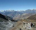
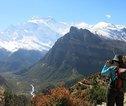
We now experience a dramatic change of scenery. Leaving the forests and vegetation of the alpine regions behind we enter the upper district of Manang, known as Nyeshang. At first, our trail follows the river closely through a deep canyon on the jeep track for a couple of hours to Brathang at 2,919m where there is now a large apple plantation. We can stop for fresh coffee and cakes (and maybe some fresh apple juice) before we begin our climb this morning. The trail then crosses the river and leaves the jeep track to climb on forest trails through fir and pine trees from where the impressive curved rock face of Paungda Danda rises nearly 1,500m from the riverbank to Dukha Pokhari, where we stop for lunch. From here we veer off to the right and take the trail that climbs away from the road track and to Upper Pisang village, where we stay in a simple lodge for the night. There is an impressive monastery in the village which we can visit in the afternoon. From here to the pass we are the closest we will be to the mountains and today the views of Annapurna 2 are particularly impressive (weather permitting) and worth all the climbing.Teahouse (sleeping altitude 3,300m)
-
7
Climb high above the valley on a wonderful high trail to Ngawal
A shorter but spectacular day for acclimatisation. From Upper Pisang we take the fantastic high-level route towards Manang via the villages of Gyaru and Ngawal. This is a wonderful walk with great views across to the Annapurnas. We start with a short descent through the forest and then we have a very steep climb up to Gyaru for a tea break. The views across the valley become ever more spectacular the higher we go. From here the trail undulates high above the river with magnificent views across the Annapurnas to Ngawal, where we stay tonight. There should be time in the afternoon to explore this pretty mediaeval village and visit the gompa. Teahouse (sleeping altitude 3,650m)
-
8
Follow the high trail from Ngawal via Julu to Manang
Another day for acclimatisation. From Ngawal we take a spectacular high trail which contours high above the valley with amazing views across to the Annapurnas and Gangapurna. As we leave Ngawal village, we pass a large chorten before the trail drops down to Julu village. We take the route which climbs steeply out of Julu onto a wonderful high trail above the valley. The trail climbs to a plateau and we contour around the valley through forests with great views across the valley to the Annapurnas and Gangapurna. The trail drops down to the pretty village of Braga, dominated by a large ancient gompa. We can stop for a cup of coffee or lunch at the Super Bakery and visit the gompa and the small tree nursery, a project that Exodus has supported for many years. Passing carved mani walls we arrive at the village of Manang at 3,530m.We have time this afternoon to explore Manang and enjoy the magnificent views of the whole Annapurna Range and the enormous icefall that crashes and rumbles down from Gangapurna. This is the part of the trek where we are closest to the mountains. Across the valley the huge bulk of Gangapurna and the Annapurnas tower way above us - the sunset and sunrise over this great amphitheatre is one of the most beautiful mountain views in the country. Manang has many bakeries and coffee shops and is an ideal place to spend the afternoon.Teahouse (sleeping altitude 3,530m)
-
9
Trek to Yak Kharka; afternoon acclimatisation walk
Leaving Manang we head towards the base of the Thorong La. We climb out of the Marsyangdi Valley and turn northwest up the valley of the Jarsang Khola. Looking back the views are ever more spectacular as we are above the forests now and pass through dry, alpine country, with scrub juniper and occasional clumps of birch. We spend tonight at a lodge in Yak Kharka. We will reach the lodge by lunchtime and in the afternoon, we will have an acclimatisation walk onto the surrounding hills. Look out for the Blue sheep that inhabit this cold, windy spot.Teahouse (sleeping altitude 4,000m)
-
10
Short half day walk to Phedi, at the foot of the Thorong La
Another short day to aid acclimatisation. The scenery becomes wilder as we continue ascending the valley. At one point we descend to cross the Jarsang Khola, then traverse a scree slope to the lone teahouses at Phedi (4,420m) at the foot of the Thorong La. Thorong Phedi can be very cold and windy. In the afternoon we can go for a walk up to Thorong High Camp which is the last lodge and is about an hour above Phedi.Teahouse (sleeping altitude 4,420m)
-
11
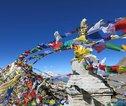
Cross the Thorong La (5416m) to Muktinath, a place of pilgrimage
A long day as we leave Phedi very early in the morning for the climb to the pass. The first part of the ascent is very steep, but it eases somewhat as we approach the top, although the altitude still makes the going tough. Eventually, after numerous false summits, we reach the pass itself at 5,416m. Ahead there is a magnificent panorama of snow-capped peaks soaring above the Kali Gandaki Valley looking towards Dolpo and Mustang and looking back we can see several of the main peaks of Annapurna. Directly in front of us is the great chasm of the Kali Gandaki, 2,500m. It's a very long descent that begins gently and becomes steeper, as we follow a series of switchbacks down to more grassy slopes. We stop for a break at Phedi where there are a few tea houses. From Phedi it’s another hour of gentle descent to Muktinath (3,700m). (Please note that conditions on the pass vary. It can be calm and clear with no snow but there can also be snow and ice and high winds on the pass. We recommend you carry Yaktrax or microspikes in case of snow or ice and take enough warm layers in case of high winds).Teahouse (sleeping altitude 3,700m)
-
12
Trek through beautiful barren landscapes to Kagbeni
An easier day after the exertions of yesterday. From Muktinath, we pass through a landscape of bare, eroded hills with a backdrop of snow-capped high peaks. After visiting the temples above Muktinath, we cross the Jhong Khola and climb up to Chongur, a small traditional village. The monastery was founded by a Sakya monk and the whole village is painted with the colours of the Sakya sect. Continuing along a mixture of trekking trails and jeep tracks we come to Jhong – another beautiful village. There is a very old monastery here dating back to the 7th or 8th Century and the ruins of an old fortress. Passing wind-eroded cliffs in an array of beautiful colours we continue down the valley through Putak village and finally have a steep descent into the Kali Gandakhi Valley and the interesting village of Kagbeni (approx. 2,800m). We have a long morning today (so take some snacks) and have a late lunch in Kagbeni.There is time in the afternoon to explore this magical place. With narrow lanes and tunnels between the houses, it has an almost mediaeval feel. (Please note that in the event that we are delayed due to bad weather, this day will be missed out and we will trek directly from Muktinath to Marpha).Teahouse (sleeping altitude 2,800m)
-
13
Follow the Kali Gandaki Gorge, beneath the great peaks of Dhaulagiri and Annapurna via Dumba Lake to Marpha
The trail now follows the jeep track down the Kali Gandaki River down to the outskirts of Jomsom, a large administrative centre, at 2,713m. Most of the time we walk along the jeep track, although at certain times of the year when the river level is low we can walk along the rocky river bed. We do not cross the river into Jomsom but instead, we stay on the left side of the valley and trek to the village of Thini, where we stop for a simple lunch. From here it is about half an hour to Dumba Lake. This very small lake is considered holy by the local Thakali people. A short climb brings us to Dumba Gompa for magnificent views of the Kali Gandaki Valley, Dhaulagiri and Tukuche Peak. From the gompa we have 2 trails – the shorter one descends down through Dumba village to the suspension bridge across the Kali Gandaki to Marpha. Another longer trail continues on the same side of the river towards the Tibetan refugee camp of Chairo. A bridge crossing the Kali Gandaki takes us to the pretty village of Marpha (2,690m) with its clean paved streets and white-washed houses. Marpha is famous for its locally-made apple and peach brandy, which you might like to sample to celebrate your crossing of the Thorong La. (Please note that in December 2019 a truck track was being bulldozed to Chairo and it was not possible to trek the longer route through Chairo. Your leader will have up to date information and will take you the best way).Teahouse (sleeping altitude 2,690m)
-
14
Continue following the Kali Gandaki Valley to Larjung
Today we follow the Kali Gandaki Valley, a major trade route. We are now in the deepest gorge in the world - to the east Annapurna I rises to 8,091m, to the west the peak of Dhaulagiri at 8,167m soars above us. Leaving the dry, barren landscapes we walk through pine, cypress and juniper forest, sometimes on the valley floor and at other times on a trail high above. From Marpha we cross back over the Kali Gandaki to avoid the road. Walking through fir and pine forests we climb up to the pretty Thakali village of Chimang. Descending to a side stream we follow the side valley down for a short while before climbing again into the forest. We ascend for about an hour and then the trail undulates for a while before descending to the valley floor at Sauru. We stop here for a break and then cross the Kali Gandaki to Kobang and on to Larjung (2,550m). We stay tonight in a simple lodge. In the afternoon we have a walk up to the village of Naurikot, another traditional Thakali village and it’s definitely worth the walk for the sunset views across the valley on Niligiri.Teahouse (sleeping altitude 2,550m)
-
15
Cross the Kali Gandaki and trek through Titi Tal, Kunjo and Jipre Deurali to Ghasa
A long day today but a fantastic trail. We start with a short walk along the road to the large suspension bridge below Larjung. After crossing the river, the trail climbs up through the forest to Titi Tal, a very small lake (pond) but an important marsh zone for waterbirds in the Mustang area. We follow the trail through Taglung and to Kunjo, where we have a simple lunch. We then descend steeply through the forest to a rocky riverbed. Crossing a suspension bridge, we have a gradual climb up to Jhipre Deurali. The trail then descends to cross the Mistri Khola and then undulates through forests of dwarf bamboo. The trail hugs the cliff with some short steep up and down sections with ropes along the side for safety. Finally, the trail comes to the old bridge across to Ghasa. Crossing the bridge, we have a short 30-minute climb up to our lodge. (Please note that the trail in the afternoon has some steep and narrow sections across landslides. For those who are not comfortable walking along such trails one of the assistant guides will take you from Kunjo to the Lete Khola on forest trails to Ghasa).Teahouse (sleeping altitude 1,950m)
-
16
Follow an undulating trail through small settlements to Tatopani, famous for its hot springs
From Ghasa we follow the road for 30 minutes and then cross the river on a new suspension bridge. The trail now climbs high above the river to Pairothaplo and then descends to Kopchepani. Across the river, we can see the huge waterfall at Rupse Chhara. We continue on the same side of the river and follow the undulating roller coaster trail up and down all morning. We have lunch in the small village of Dharap and continue through Narcheng and past a hydroelectric project just before Tatopani. A suspension bridge brings us right into Tatopani, where we spend the night. Tatopani means ‘hot water’ and is famous for its hot springs just below the village and there is time in the late afternoon to enjoy a welcome soak - guaranteed to ease any aching limbs!Teahouse (sleeping altitude 1,250m)
-
17
A long climb up through the villages of Ghara, Shika and Chitre to Ghorepani
The last stage of the trek takes us over a high ridge to the end of the trek. Today is a sting in the tail as we have a long climb to Ghorepani. The trail climbs all day through small hamlets and terraced fields. We start with a short descent on the road track for 45 minutes to a couple of bridges. From the second bridge, we have 30 minutes along a track and then the trail starts climbing on a series of stone staircases. It’s fairly steep up to Durbin Danda from where we have a short descent through Ghara. We then mostly follow the old trail as it climbs up through the villages of Shika and Chitre. From Chitre we enter a huge rhododendron forest and the last couple of hours take us up to Ghorepani. Meaning ‘horse water’, Ghorepani was once a stopping place for the huge mule trains that used to ply this route. As we climb today the mountains start to appear and from Ghorepani we get fabulous views of the Annapurnas from the lodge.Teahouse (sleeping altitude 2,900m)
-
18
Optional early morning walk up Poon Hill for sunrise before a long descent to Birethanthi
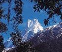
An early start for those who want to trek the hour up to the top of Poon Hill for the sunrise (approx. two hours return trip including stops - in addition to the 7.5hrs walking to Birethanthi). The effort is well worth the 310m climb (again, in addition to the 320m of total ascent today) for the superb views over the Annapurnas, Dhaulagiri and Machhapuchhare. We return to our lodge for breakfast and then it’s all the way downhill today through the forest to Banthanti and then down a stone staircase through Ulleri and Tirkhedunga to Birethanti by the Modi Khola, where we stay in a very simple lodge.Teahouse (sleeping altitude 1,025m)
-
19
Short walk to Naya Pul and drive to Pokhara; afternoon free
From Birethanti it is a very short walk to Naya Pul, where we will pick up transport back to Pokhara. We usually arrive by lunchtime and have the afternoon to explore this pretty lakeside town.Hotel Lakefront / Hotel Dahlia (or similar)
-
20
Free day in Pokhara
We have the whole day in Pokhara. There are many options to choose from today. You might want to hire a bike and cycle around part of the lake, or you could take a boat across the lake and walk up to the Japanese Peace Pagoda with great views of the mountains and the lake (from the pagoda carry on up the ridge to Raniban Resort for lunch), or you might want to visit the Mountaineering Museum, the Gurkha Museum, take a trip to the nearby Tibetan refugee settlement and craft centre, or simply relax in one of the many lakeside restaurants and stroll around the shops.Hotel Lakefront / Hotel Dahlia (or similar)
-
21
Fly to Kathmandu
We fly to Kathmandu. Weather depending there should be good views on the flight.Hotel Royal Singi (or similar)
-
22
End Kathmandu
The trip ends after breakfast. Those not on the group flight will leave us after breakfast.